
There is something quietly joyful about landing in a new city and knowing you do not need a car at all. You step off the plane or train, tap your card at the gate, and you are already on your way into the centre with everyone else. No haggling with taxi drivers, no stress about parking, just an easy start to your trip.
Some cities make this feel almost effortless. Frequent buses, trams, and trains, clear maps and signs in the stations, simple ticket options, and well lit, clean platforms all help you relax and look around instead of staring at your phone in a panic. A good link from the airport or main station straight into the heart of town is a big part of that too.
In this guide, we will look at cities that are genuinely easy to explore by public transport, whether you are planning a quick weekend break or staying for a longer trip. These are real places that travellers return to again and again because getting around is simple, safe, and often quite scenic. As a bonus, using buses and trains is usually cheaper than hiring a car, and it is kinder to the environment as well.
If you are dreaming of a car free city break, this list should help you find the right place to start.
What Makes A City Easy To Explore By Public Transport?
Some cities feel friendly the moment you step onto a tram or train. You do not need to study a map for an hour, or panic every time you change lines. You just tap, ride, and look out of the window.
For this list, the cities all share the same core traits. They have simple networks, clear information, and stress free ways to pay. You do not need to be a local, or speak the language well, to feel comfortable using them.
Think of it as a test: could a tired traveller, with a small suitcase and no data on their phone, still get into the centre without trouble? If the answer is yes, then that city has probably done something right.
Simple, Frequent And Reliable Transport Options
The easiest cities give you more than one way to get around. You can usually mix:
- Metro or underground lines for fast cross city trips
- Trams or light rail for shorter hops through central areas
- Buses to reach neighbourhoods between the main lines
- Local trains to outlying districts, beaches, or nearby towns
- Ferries or cable cars where the landscape calls for them
You do not have to use all of these of course. The key feeling is that you have options, and they are all fairly easy to understand.
Frequency matters just as much as choice. In the cities on this list you will often notice:
- Short waiting times in the day, often 5 to 10 minutes
- Regular services in the evening, not just at rush hour
- Some sort of late night or night bus network on key routes
This kind of pattern changes how you travel. You stop planning every trip like a military exercise and start thinking, “If I miss this one, another will come soon.” That small shift takes away a lot of stress.
Reliability is where everything comes together. When services arrive when they are meant to, you can:
- Fit more sights into a short stay
- Arrange timed tickets for museums without anxiety
- Take little side trips outside the centre and still be back for dinner
Tourists often have limited days and fixed bookings. A delayed bus or a cancelled train can mean a missed entry slot or a lost evening. Cities that appear in this guide have systems that most visitors describe as predictable, even when they are busy.
Easy Tickets, Travel Cards And Contactless Payment
Ticketing is where many trips either feel smooth or fall apart. The easiest cities keep things straightforward, with a few clear choices instead of a wall of confusing tariffs.
Look out for:
- Day passes that let you ride as much as you like in a 24 hour period
- City travel cards that cover buses, trams, metro, and often local trains on one ticket
- 48 or 72 hour passes, handy for weekend breaks
- Weekly passes if you are staying a little longer
The best systems cover a whole urban area under one fare zone, or at least keep the zones simple. You should be able to land at the airport, buy one product, and use it everywhere you need for the length of your stay.
Contactless payment has changed things a lot. In many easy cities you can:
- Tap in and out with a contactless bank card
- Use a mobile wallet such as Apple Pay or Google Pay
- Forget about buying a ticket for most everyday trips
A nice feature to look for is daily or weekly fare caps. This means:
- You tap your card each time you travel
- The system adds up your journeys
- Once you have spent the cost of a day or week ticket, further rides are free
You get the savings of a pass without needing to decide in advance. It feels very relaxed.
Another handy sign of a visitor friendly city is simple airport to city centre tickets. Many places offer:
- A clear flat fare from the airport into the central zone
- A return ticket at a small discount
- Airport journeys included in the main day or city pass
When this is well set out, you can leave the terminal and be on your way in minutes, rather than trying to decode a fare chart by the ticket machine.
Clear Maps, Signs And Help For Visitors
Even the best network feels stressful if you cannot read it. The cities in this list tend to treat maps and signs as part of the welcome.
You often see:
- Colour coded lines with clear end station names
- Simple diagram style maps in carriages and at stops
- Street level maps around stations so you can find your bearings
Multilingual signs help a lot, even if you speak some of the local language. Directions to platforms, exits, and key landmarks are usually shown in at least two languages, often more. This keeps you from freezing at a junction, wondering which tunnel to follow.
Apps and digital tools also play a part. Visitor friendly systems usually offer:
- An official journey planner app with live departure times
- Disruption alerts in clear, non technical language
- Offline maps you can save for later
Inside vehicles and stations, audio and visual announcements matter more than you might think. Clear screens that show the next stop, paired with spoken announcements, help:
- People who are hard of hearing, who can watch the screens
- People with sight loss, who can listen for their stop
- Anyone who does not speak the language well, as they can match what they hear with what they see
All of this reduces that low level worry that you will miss your station or end up miles away from where you meant to be.
Tourist information desks or small help points in major hubs are the final touch. Even if you never use them, seeing a staffed counter nearby helps you feel that you will not be stuck if things go wrong.
Safety, Accessibility And Comfort For All Travellers
A city can have fast trains and clever apps, but if you do not feel safe, you will not enjoy using them. When you arrive in a truly easy city, small details reassure you straight away.
You might notice:
- Good lighting on platforms, bus stops, and walkways
- CCTV cameras in stations and on vehicles
- Staff on duty in central stations, not just in a back office
- Clear walking routes between stops, often with marked pedestrian crossings
This does not mean nothing bad ever happens, of course. It does mean you feel able to use the system in the evening, or travel alone, without constant unease.
Accessibility is another quiet test. The best cities try to make sure that:
- Stations have lifts or ramps, not only stairs
- Trams and buses are low floor, so you can roll straight on
- There are marked spaces for wheelchairs, prams, and luggage
- Ticket machines and gates are wide enough for mobility aids
Even if you do not need these features yourself, you will feel the difference. Families, older travellers, and people with injuries or long term conditions all move more freely. The whole experience feels calmer.
Comfort is not luxury, it is basic care. Look for:
- Clean, modern vehicles with decent ventilation
- Platforms and carriages that are free from rubbish and strong smells
- Simple seating, both in vehicles and while waiting
- Some shade or shelter at stops in hot or wet weather
When a tram glides in quietly, with big windows and enough space to stand without being crushed, you stop treating transport as a chore. It becomes part of the trip, like a moving viewpoint across the city.
These are the details that shaped the list of cities in this guide. Places where you can trust the network, pay with a quick tap, read the signs without stress, and feel safe and welcome at every stage of your journey.
Top European Cities That Are A Joy To Explore By Public Transport
Europe is full of cities where public transport feels almost like a sightseeing tour on rails. You tap your card, grab a seat by the window, and the city starts to unfold in front of you. No parking apps, no ring roads, just an easy rhythm of stations, stops, and short walks.
These four cities are classic examples. They have dense networks, simple ticket options, and very straightforward routes from the airport or main station into the centre. You can land in the morning and be on the museum steps, or by the river, before lunch.
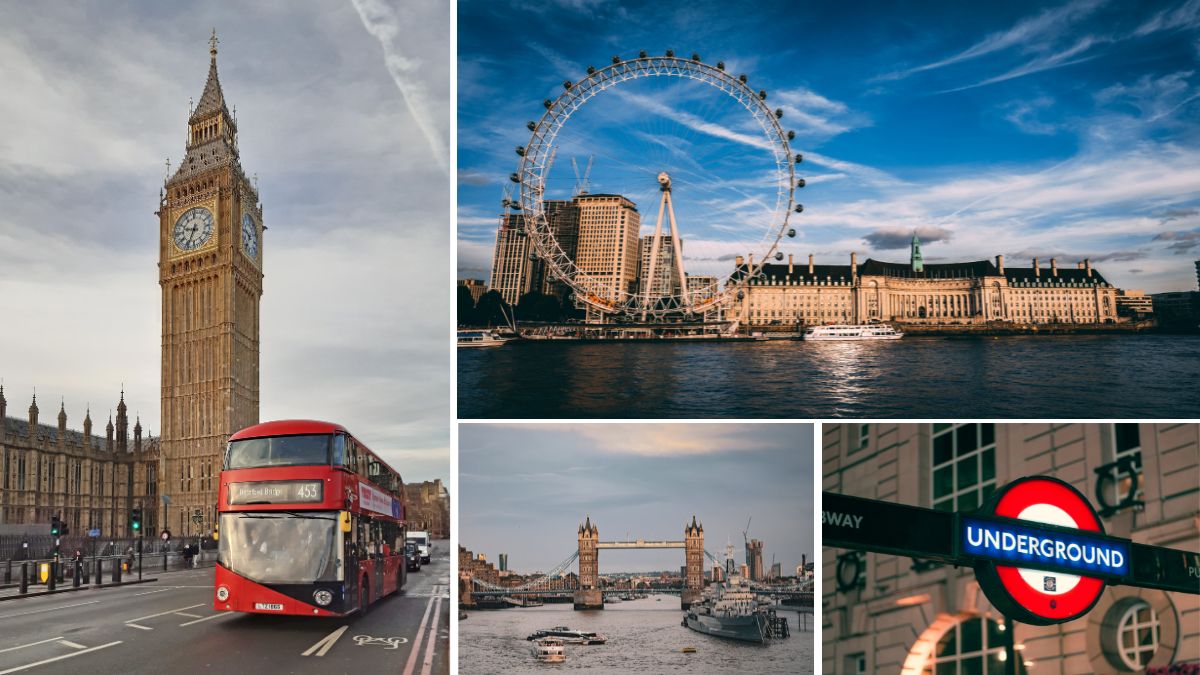
London: Tap In, Ride The Tube, And See The City Car Free
London looks huge on a map, yet it feels surprisingly manageable once you drop into the transport network. The Underground, Overground, buses, trams, and Docklands Light Railway (DLR) all slot together like one big system, with that familiar roundel logo guiding you from street to station.
The Tube is still the core for most visitors. Lines are colour coded, stations are well signed, and you are rarely more than a short walk from a platform in central areas. The Overground and DLR fill in the gaps, gliding through neighbourhoods that sit just beyond the traditional tourist core, while red buses stitch everything together at street level. You see more of daily life from the bus, and the routes along the Thames or through the West End are almost like low cost sightseeing tours.
Payment is the part that really makes London feel easy. You can use an Oyster card or a contactless bank card or phone, and the rule is simple: tap in at the start of your journey, tap out at the end. On buses and trams you only tap when you get on. The system caps your daily spend, so once you reach the cost of a day travelcard, extra rides are free. There is no need to guess how much you will travel, you just move around and let the cap look after you.
Most of the big sights sit right on the network.
You can:
- Step off at Westminster for Big Ben and the Houses of Parliament
- Ride to South Kensington for the museums and a stroll to Hyde Park
- Use the Jubilee line for the South Bank, the City, and Canary Wharf
- Hop on a bus for views of Trafalgar Square, Covent Garden, and the Strand
Airport links are as simple as you could hope for in a city this size. The Elizabeth line connects Heathrow to Paddington, the West End, the City, and Canary Wharf in one smooth ride, with contactless payment and daily caps just like the Tube. The Piccadilly line on the Underground also runs to Heathrow, handy if you prefer a cheaper trip and do not mind a few extra stops. From Gatwick, the Gatwick Express runs to Victoria, while regular Southern and Thameslink trains offer slightly slower but cheaper options to different central stations.
Once you have done one airport trip, the rest of London starts to feel very approachable without a car.
Paris: Metro And RER Trains To Every Museum And Neighbourhood
Paris has a transport map that looks a little like a plate of spaghetti at first glance, but the reality on the ground is calm enough. The Metro is one of the densest urban rail networks in the world, with stations tucked close together so you are rarely far from an entrance. This is why you can zip from the Eiffel Tower area to the Marais or Montmartre with only one or two changes.
The Metro lines are numbered and colour coded, and the platforms are well marked with the names of the end stations. Once you get the hang of that, the system feels logical. Above ground, buses are useful for short hops and for late evenings when you want to keep an eye on the city as you travel. The RER trains act like express lines, linking the centre to the suburbs, Versailles, and Disneyland Paris. RER A to Disneyland is very popular with families, and tickets are sold in a simple bundle at machines and counters.
Tickets and passes are much more visitor friendly than they used to be. You can buy single tickets, or go for day passes like Navigo Easy or Navigo Jour products that cover buses, Metro, trams, and RER in the central zones. Contactless bank cards are now accepted on many trips within Paris, which means you can move around without constantly buying paper tickets. It feels closer to London every year in that sense.
Public transport drops you at the door of the classics. The Louvre, Orsay, Notre Dame, the Eiffel Tower, the Latin Quarter, and Montmartre all sit within a short walk of a Metro or RER station. It is quite normal to see visitors stepping off the train, spotting the little brown museum signs, and just following them out into the light.
Airport access is equally direct. RER B runs to Charles de Gaulle (CDG) and into central Paris, stopping at hubs like Gare du Nord and Saint Michel. From Orly, you can use the Orlyval light rail to link into RER B, or take tram and bus options depending on where you are staying. You do not need a taxi unless you really want one, which sets the tone for a very relaxed, car free stay.

Berlin: Straightforward U Bahn, S Bahn And Trams For First Time Visitors
Berlin feels quite spread out, yet its public transport makes the city fall into clear, easy sections. The U Bahn (underground), S Bahn (suburban rail), trams, and buses all sit on top of a simple zone map marked AB, BC, and ABC. Once you know which zone your hotel is in, and whether you will head out to the edge of the city, picking the right ticket becomes painless.
The U Bahn covers most central and inner neighbourhoods with frequent trains and clear signage. The S Bahn acts like a ring and spine, circling the city and shooting through the middle. Trams are more common in the east of the city, while buses fill in gaps and help with shorter local trips. Services usually run on a reliable, high frequency pattern, so you rarely stand on a platform for long.
Tickets are simple and good value. You can buy single trips, day tickets, or group tickets, all valid across U Bahn, S Bahn, trams, and buses within your chosen zones. Group tickets are especially handy if you are travelling with friends or family, as one pass covers everyone. Machines switch to English at the press of a button, and you validate your ticket once at the start of your journey, then hop on and off as you please.
For visitors, the comfort lies in how easy it is to reach different characterful areas. Mitte has many of the classic sights and museums, linked by both U Bahn and S Bahn. Kreuzberg is simple to reach on lines like U1 or U7, with lively streets that run right beside the tracks. Prenzlauer Berg is tied into the network through tram routes and U Bahn stops, which makes café hopping in that area a relaxed affair even late in the evening.
Airport and main station links keep everything joined up. From Berlin Hauptbahnhof (the main station), U Bahn, S Bahn, trams, and buses fan out in all directions, so you can treat it as an anchor point. Newer airport rail links from BER Airport run straight into the city on regional trains and the S Bahn, with ABC tickets covering the full journey. You can land, buy one ticket, and step off the train in the centre in under an hour.
Amsterdam: Trams, Metro And Bikes Working Together
Amsterdam is one of those cities where walking, cycling, and public transport all blend into one smooth experience. The centre is compact, the canals are your natural compass, and the trams act like moving signposts, gliding past gabled houses and café terraces all day long.
The tram network is the heart of city travel for many visitors. Routes fan out from Amsterdam Centraal station to the museum quarter, the Jordaan, De Pijp, and outlying residential areas. Trams are clean, frequent, and clearly numbered, with digital displays and stop announcements that make it easy to hop off at the right place. The Metro runs in simple lines that extend further out, handy if you are staying near newer districts or heading to Amsterdam Noord, which sits across the water.
Tickets are integrated across trams, buses, and Metro, which keeps life simple. You can buy short term GVB passes that cover 1, 2, or 3 days, and use them on all local services. Contactless payment is also available, so you can tap in and out with a bank card rather than buying paper tickets. Many visitors like to mix this with bike rental, riding a few short legs then using a tram or Metro line when legs get tired or rain appears.
The layout of the network matches the rhythm of a city break quite well. From Centraal station you can ride straight to the Rijksmuseum and Van Gogh Museum, wander through the canal belt, then carry on into neighbourhoods like De Pijp, known for its cafés and the Albert Cuyp Market. The ferry and Metro links across the IJ make Noord easy to visit too, with its mix of creative spaces, parks, and waterfront views.
Airport access is simple and fast. From Schiphol Airport, frequent trains run straight into Amsterdam Centraal in around 15 to 20 minutes. Tickets are easy to buy from machines or via contactless options at the gates. Once you arrive at Centraal, trams and Metro lines are all in front of you, which makes it very hard to feel lost, even on a first visit.
Barcelona: Metro, Buses And Funiculars To Beaches And Hills
Barcelona has a transport network that matches its mix of sea and hills. The Metro is clean and modern, with air conditioned trains and clear signage. It runs beneath the city in a web of lines that cut from the Gothic Quarter to Eixample, from Sants to the Sagrada Família, and beyond to residential areas you would never reach on foot.
Buses and trams add extra layers on the surface, while the funiculars carry you up into the green slopes that frame the city. The Montjuïc funicular links the Metro with the hilltop parks and viewpoints, which means you can leave the beach and be looking out over the port within a short, scenic ride. Along the coast, buses and trams keep the different beach areas connected, so you can pick a stretch of sand that suits your mood without thinking about parking.
Tickets are simple and integrated. Passes like the Hola Barcelona card cover Metro, buses, trams, and local trains within the main urban zones for a fixed number of days. The regular T casual and other multi journey options are popular with both locals and visitors, as you can share them within a group. You tap or validate once and then you are free to change between modes within a set time without paying again.
The joy of Barcelona without a car is how close everything feels once you trust the network. You might spend the morning in the Gothic Quarter, take a short Metro ride to Sagrada Família, then head down to Barceloneta beach for a late lunch. In the evening, a quick trip up to Montjuïc or Tibidabo gives you that classic balcony view over the city lights. All of this happens with a few short rides and straightforward changes.
From the airport, it is easy to start as you mean to go on. Barcelona El Prat links to the city by aerobus, suburban trains, and Metro line L9 Sud, each with clear signs in the terminal. Trains and the Metro connect into key hubs such as Sants and Passeig de Gràcia, where you can switch to the rest of the network. You step out into the centre with your pass already in hand, and from that point, a car feels completely unnecessary.
Cities Around The World Where Public Transport Makes Travel Easy
Once you step beyond Europe, you start to see just how good public transport can be when a city plans around it. Trains that glide out of the airport, ferries that feel like mini cruises, and ticket cards that work almost everywhere you tap. You can land in the morning, freshen up, and be in a lively neighbourhood before your coffee has cooled.
These cities are the sort of places where a hire car feels like extra admin. You move around with a light bag, a simple card, and a clear sense that the whole network has been set up for everyday life, not just commuters in suits.
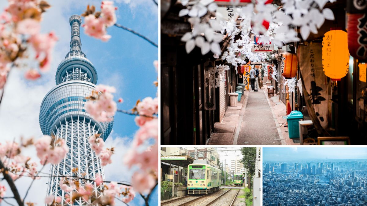
Tokyo: Ultra Reliable Trains And Metro For Stress Free City Hopping
Tokyo is the place that finally convinces many people that big cities do not have to be stressful. The rail map looks like a plate of coloured spaghetti at first, but once you ride a couple of lines, it starts to feel oddly gentle.
The JR lines, Tokyo Metro, and Toei Subway tie together a huge city in a very calm way. Trains come every few minutes, they run from early morning until late at night, and they are famously punctual. If the timetable says 10.12, you can almost set your watch by it.
On the map, you see bold colours, clear line names, and little station codes like G09 or M16. Those codes are your secret friend when you are tired. Each station has a number and a colour that match the line, so even if you forget the full Japanese name, you can still find your way without drama. Platforms and ticket machines have English signs and language options, and announcements on the trains repeat in English too.
Payment is simple once you have an IC card. Suica and PASMO are the classics. You load money onto them, then just tap in and out on:
- JR trains
- Metro and subway lines
- Most local buses
- Many convenience stores and vending machines
For a visitor, it feels like a magic key. No need to work out a new fare every time you move across town.
From the moment you land, the trains shape your trip. Narita Express (NEX) runs straight from Narita Airport into major hubs such as Tokyo Station and Shinjuku. From Haneda Airport, you can take the Tokyo Monorail to Hamamatsucho or use the Keikyu line, both linking into the main rail web. You step onto that first train and you are already travelling like a local.
The main sightseeing areas all sit on or near key lines:
- Shibuya on the JR Yamanote line and several Metro routes
- Shinjuku with its maze of platforms but clear signs and exits
- Asakusa on the Ginza and Asakusa lines, handy for temples and old streets
- Akihabara on the Yamanote and Keihin Tohoku lines, ideal for electronics and anime fans
You can string them together in any order, hopping from neon to shrines to backstreet bars, and you rarely wait more than a few minutes for the next train.
Singapore: Clean, Safe MRT And Buses Across A Compact City
Singapore feels like the travel version of a tidy desk. Everything has its place, the instructions are clear, and the MRT does much of the heavy lifting for you.
The network is not huge compared with Tokyo, but the lines you need as a visitor cover almost every key area. Trains are air conditioned, platforms are spotless, and stations sit close to the main sights. You glide into the city on the East West Line from Changi Airport, and in around half an hour you can be changing trains under the skyscrapers.
What stands out for many people is how simple payment feels. You can:
- Tap in and out with a contactless bank card
- Use your phone wallet
- Or pick up a stored value card like EZ-Link or NETS FlashPay
The same tap works on both MRT and buses, so you do not need to worry about different tickets for different modes.
Signs and station layouts feel made for visitors. Everything important appears in English, from platform numbers to exit letters. Lifts and escalators are easy to find, and many stations have direct links into shopping centres, which means shade and coffee during a hot afternoon.
The main areas people talk about on a first trip are almost all on the MRT grid:
- Marina Bay and Gardens by the Bay
- Chinatown for temples and food streets
- Little India for markets and colour
- Orchard Road for shopping
- Bugis and Kampong Glam for a mix of cafés and heritage
You ride a few stops, walk a short distance at street level, and you are there. Buses fill in any gaps if you want to go out to neighbourhoods like Tiong Bahru or to the zoo.
The train from Changi Airport is the detail that really sets the tone. You leave the arrivals hall, follow clear MRT signs, tap your card, and sit in chilled air as the city comes into view. No taxi queue, no fuss, just a smooth slide into the centre of things.
Hong Kong: MTR, Trams And Ferries Linking City, Harbour And Islands
Hong Kong feels almost made for people who love public transport. The MTR forms the spine of the city, and everything else hangs from it like little branches and loops.
The MTR lines are colour coded and easy to read, with clear route maps and station codes. Trains run fast and often, with platform screen doors, which adds a sense of calm even when things are busy. Air conditioning is strong, which you will be grateful for after a humid walk outside.
The piece that makes it all feel so smooth is the Octopus card. You load money on once, then tap on:
- MTR trains
- Buses and minibuses
- Old double decker trams on Hong Kong Island
- Ferries, including the Star Ferry
- Many shops, bakeries, and supermarkets
You get into a rhythm of small taps, short trips, and no queues at ticket machines.
Transport is not just about getting from A to B here, it becomes part of the soundtrack of the trip. The Star Ferry between Tsim Sha Tsui and Central gives you those postcard skyline views for a tiny fare. The old green and cream double decker trams rattle along the north side of Hong Kong Island, past markets and side streets, at a relaxed pace that feels almost from another age. The Peak Tram pulls you steeply up to Victoria Peak, where you can watch the harbour and islands spread out below you.
From the airport, things stay just as easy. The Airport Express runs from Hong Kong International Airport to stations like Tsing Yi, Kowloon, and Hong Kong Station in Central. Trains are fast, the seats are comfy, and in some cases you even get in town check in, where you can drop your luggage at the station for certain airlines. After that, the MTR and local transport pick up the story and carry you to your hotel or guesthouse.
For a visitor, this mix of trains, trams, and boats turns the city into a chain of scenes rather than a set of chores. You tap in, ride a few stops, and every change of vehicle adds a fresh view over the water or the hills.
Vancouver: SkyTrain, Buses And SeaBus For A Car Free City Break
Vancouver has the feel of a city that wants you outside rather than stuck in traffic. The public transport network pairs well with that, particularly the SkyTrain, which often glides above ground with mountain and harbour views on both sides.
The SkyTrain is a driverless light metro, which gives it a slightly futuristic feel as it snakes through the city. Lines like the Canada Line link Vancouver International Airport (YVR) with Downtown in around 25 minutes. You roll your suitcase onto the train, sit by the window, and watch the suburbs melt into the glass towers of the centre.
Tickets and passes are integrated across:
- SkyTrain
- Buses
- The SeaBus passenger ferry to North Vancouver
You can buy stored value cards like Compass Card, or use contactless payment in many cases. Once you have that set up, you tap in at stations or on buses and the system works out the fare by zone.
For a first visit, the network covers almost everywhere you would want to go without a car. You can:
- Ride into Downtown for the seawall, shopping streets, and Stanley Park
- Take a short walk or bus ride into Gastown for cobbles and cafés
- Hop on the SkyTrain to reach Commercial Drive, with its indie food spots and small bars
- Use the SeaBus to cross to Lonsdale Quay and waterfront views back to the city
The structure suits people who like a relaxed, outdoors focused break. You spend the day walking or cycling, then jump on a train or bus when your feet complain.
That first trip from the airport sets the mood very clearly. There is no need to bargain with a taxi driver or worry about price. You follow the signs to the Canada Line, tap your card, and in a short ride you are already in the thick of things, ready to drop your bag and head straight to the waterfront.
Sydney: Trains, Light Rail And Ferries To Beaches And Bays
Sydney stretches out around coves, headlands, and long beaches, yet it is still one of the easiest cities to explore without a car. Its mix of trains, buses, light rail, and ferries means you can hop between city centre, harbour, and surf without touching a steering wheel.
Payment is centred on Opal. You can use an Opal card or simply tap on and off with a contactless bank card or phone. The same tap works on almost everything, including:
- Trains
- Buses
- Light rail
- Ferries across the harbour
Daily fare caps keep costs predictable, so you can roam around without worrying that each extra trip will blow your budget.
From Sydney Airport, suburban trains run straight into Central station and onwards to key city stops. The journey is short, and once you arrive at Central you are staring at a map that takes you out in every direction. You can drop your bag and be at Circular Quay, looking at the Opera House and Harbour Bridge, in almost no time.
The ferries are the real joy for many visitors. The Manly ferry gives you that classic sweep out of Circular Quay, past the heads, and into a laid back beach suburb with surf and gelato. Other routes link you to places like Watsons Bay and Taronga Zoo, so half the sightseeing happens on the water.
Trains and buses take care of the rest. You can ride out towards Bondi Junction then catch a bus down to Bondi Beach, or head on to Coogee and other sandy stretches further along the coast. Light rail lines serve areas like Darling Harbour, Pyrmont, and parts of the inner west, which makes evenings out feel very straightforward.
Sydney is large, but once you trust the network and your little tap on, tap off habit, the city shrinks to a string of bays, viewpoints, and swimming spots, all laid out along well used routes that locals rely on every day.
How To Plan A Trip Around Public Transport And Enjoy It
Planning a car free trip is a bit like setting up a gentle track for yourself. Once you do the thinking in advance, you can just glide along it, without second guessing every move. A little prep around routes, passes, and where you stay will turn buses, trams, and trains into the easiest part of your holiday, not the scary bit in between the fun.
Think of this section as your simple toolkit. Use these habits in London, Tokyo, Vancouver, or any of the cities in this guide, and you will feel much more relaxed from the moment you land.
Research Routes, Passes And Apps Before You Land
The calmest trips usually start a few days before you fly, with a cup of tea and a quick look at official websites.
Begin with the bare basics:
- Airport to city routes
- Day passes and tourist cards
- Official transport apps and offline maps
Search for the city name plus terms like “public transport”, “airport to city”, or “tourist travel card”. You are looking for the official site from the local transport authority, not a random blog or third party reseller. These sites often have a section called “Visitors” or “Plan your trip” with neat summaries in English.
On the airport page, check:
- Which train, metro, bus, or tram runs into the centre
- Rough journey time and where it stops
- Whether your route is included in regular travel cards or needs a special ticket
If you already know your hotel, see if any of those lines stop nearby. It feels very good to land and already know, “I need the green metro line to X station, then a 5 minute walk.”
Next, look at passes and tourist cards. Many cities have:
- Pure transport passes for 24, 48, or 72 hours
- Tourist cards that bundle transport plus museum entries or discounts
Open a notes app or small notebook and jot down:
- Names of passes
- What they cover
- Prices
- Any airport inclusion
You do not need to memorise everything. You just want a rough sense of which option is likely to suit your stay, so you are not staring at a ticket machine in a jet lagged fog.
Two apps help almost everywhere:
- The official public transport app from the city or region
- A maps app with offline access, such as Google Maps with areas downloaded
On the transport app, look for:
- Journey planner with route suggestions
- Live departure times
- Disruption alerts
On your maps app, download the city so it works offline, then star or favourite key places:
- Your hotel or hostel
- Main train station
- Airport link station or stop
- A few headline sights you know you want to visit
On the day you arrive, those little stars feel like handrails. Even if your roaming fails, you still have a simple map that works without data, with the places that matter already pinned.
Choose A Place To Stay Near A Major Station Or Line
A smart hotel location can make the whole city feel closer. Instead of chasing the “cutest street” or “trendiest district” on Instagram, focus on staying near one strong transport link.
You do not need to be on top of a landmark. You want to be close to:
- A busy metro or underground line
- A main tram route
- A big hub station where lots of lines meet
Open a map that shows both attractions and transport lines. Many booking sites now overlay metro routes, but you can also lay a transport map next to your hotel search and flick between them.
A simple method that works in most cities:
- Pick two or three areas you like the look of.
- Check which metro or tram lines serve them.
- See how many changes it takes from those lines to reach key sights you care about.
- Favour the place where you can reach most of those spots with no more than one change.
For short stays, a hotel near a direct airport link is a small luxury that pays for itself in saved time and stress. If the airport train or bus drops you within a 5 to 10 minute walk of your bed, your arrival and departure days feel instantly lighter. You avoid long transfers with luggage and confusing late night changes.
You also gain a simple anchor in your mind. After a day out, you only need to think, “I just have to find Line 2 back to Central Station, then walk three blocks,” rather than constructing a complex route from scratch.
Use Local Travel Cards To Save Money And Time
Buying the right pass at the start of your trip feels a bit like putting fuel in the tank once, then forgetting about it. No more queuing at machines for every single ride.
Many cities offer a mix of:
- Single tickets for one journey
- Day passes for unlimited travel in 24 hours
- Multi day cards for 2 to 7 days
- Tourist passes with transport plus attractions
Before you travel, compare a couple of rough scenarios:
- Count how many journeys you are likely to make in a day. Airport into town, out to a museum, across to dinner, home again, maybe a side trip later.
- Multiply single ticket prices by that number.
- Compare the total with the cost of a 24 or 48 hour pass.
If you are staying three days or more, take a look at the price of longer cards. Some cities add museum entries, boat trips, or discounts on tours, which can make them surprisingly good value if you like to fit quite a bit into each day.
As soon as you arrive, buy your chosen card straight away. Airports and main stations often have:
- Ticket desks with staff who can switch to English
- Machines with language options and clear pass names
- Tourist information counters that sell city cards
Buy once, tuck the card into your wallet or phone case, and forget about it until you leave. The habit you want is simple: tap in, ride, tap out, enjoy. No fishing for coins, no extra queues, no panicked hunt for the right fare while locals wait behind you.
If the city uses contactless bank cards with daily caps, that can act like a pass without the label. In that case, your planning is even easier. Just use the same card for each trip and let the system work it out in the background.
Stay Safe And Confident On Buses, Trams And Trains
Safety on public transport does not have to be a dark subject. With a few quiet habits, you can feel just as secure on a city tram as you do walking around your own neighbourhood.
Start with your valuables. Keep your phone, wallet, and passport in:
- A zipped bag worn in front of you
- An inside pocket that closes
- A money belt under your clothes if you feel happier that way
On busy metro lines and tourist routes, pickpockets look for easy chances, not drama. A simple zip and a hand on your bag in crowds removes much of that chance.
On platforms, stick to the basics:
- Stay behind the yellow or white safety line.
- Let people get off before you try to board.
- Watch your step around gaps between train and platform.
When it is late and you are tired, choose carriages with more people in them, not the very empty ones at the far ends. In some cities, women and families often cluster near the front or near the driver. Follow local patterns if they make you feel more at ease.
If you ever feel unsure, ask staff for help. Most networks have:
- Visible staff in big stations
- Drivers or conductors on trams and buses
- Help points or intercom buttons on platforms
Point to your card or a station name on your phone if you do not share a language. Many people are used to helping visitors and will simply point you to the right platform or exit.
In crowded places, like bus stops outside big attractions or packed central stations, take it slowly. Give yourself an extra few minutes so you do not feel rushed. When you are not in a hurry, you are less likely to drop something, jump on the wrong train, or forget a bag by your feet.
Most of all, trust that you belong there. Locals use these buses, trams, and trains every day to get to school, work, and home for dinner. You are just joining in for a few days, with your own small list of stops to tick off. Once you settle into that rhythm, public transport becomes part of the pleasure of the trip, not something to be nervous about.
Conclusion
Some cities make travel feel almost effortless, with public transport that keeps you moving without a car, saves money, cuts stress, and quietly helps the planet at the same time. The trick is to pick the place that suits you, whether you care most about short journeys, clear English signs, easy airport links, or a tram that drops you right by your favourite kind of neighbourhood.
Have a look at the cities in this guide and choose one that matches your own priorities, then treat your pass or contactless card as your ticket to explore, not a source of worry. Try at least one of these car free cities on your next trip and notice how quickly you settle into the rhythm of tapping in, riding, and stepping out somewhere new. Once you have learned how to use public transport in one city, you will find the next one feels far less mysterious, and the world of car light travel starts to open up.